Sights of Brighton & Hove 2022

Working on my ‘Thirty Walks from Brighton Station’ to be published 2022 I headed with Dan Foden to Hove Lagoon via Brighton’s remarkable Seven Dials junction, St Mary & St Abraam Coptic Church heading left down Palmeira Avenue. The palmeira (Portuguese for palms) were gathered for a vast conservatory for exotic plants that collapsed spectacularly the day before its scheduled opening in 1833. After Brighton & Hove Reform Synagogue (1966) we turned onto Eaton Road and took a detour right for Sussex County Cricket Club. The picture of Dan was taken near Sussex Cricket Museum, open on match days, showing the cricket ground famed also as a concert venue.

Working on my ‘Thirty Walks from Brighton Station’ took me back to New Church Road where I used to work at Chichester Diocesan Office. The Jaipur Gate (1886) is at the opposite (east) end of New Church Road to my former workplace. Its a relatively recent arrival (2006) to the garden of Hove Museum & Art Gallery. Donated by the Maharajah of Jaipur the gate has inscriptions in English, Sanskrit and Latin. These applaud both the British empire and the east through puns: ‘ubi virtus ibi victoria’ (where virtue lies so does victory/Victoria) and ‘ex oriente lux’ (light comes from the east/East). The museum has free admission but is closed Tuesday and Wednesday.

‘Does this train stop at Brighton? I hope so or there’s going to be a hell of a splash!’ (Kenny Everett) Good walks from Brighton Station are more north, east and west than south on account of the sea. The old South Street of The Lanes is now underwater. Walking in Brighton is inspired yet limited by the seaside. ‘Thirty Walks from Brighton Station - catching sights and sea air’ is the fruit of my twenty year association with the city of Brighton & Hove including service on the City Forum 2001-9 and ongoing ministry as assistant priest at St Bartholomew’s Church. Over that period my knowledge of sights has expanded from the popular duo of Pier and Pavilion to the two hundred and sixty six listed in this book. Thirty walks are listed in rough order of length from one mile up to eighteen. All start from Brighton Station. Twenty one walks are circular. Nine exploit public transport for the return journey. Detailed walk routes are provided alongside schematic illustrations which give the overall feel of each walk and its major sights. The circular walks head north through Brighton Greenway and Preston Park to Patcham, Stanmer House and Hollingbury Camp, east to The Level, Lewes Road Cemetery, Hanover, Queen’s Park, Brighton Racecourse, Kemp Town, Brighton Marina and Ovingdean, west to St Ann’s Well Gardens, Hove Park and Southease and south to North Laine, Royal Pavilion and Palace Pier. Other walks extend radially to Shoreham, Devil’s Dyke, Chattri Memorial and Saltdean with longer excursions to Bramber Castle, Truleigh Hill, Jack & Jill Windmills, Ditchling Beacon, Lewes, Southease, Telscombe and Newhaven. Sketch by Malcolm Trollope-Davis exhibited on Brighton Station.

This book is the fruit of my romance with Brighton exploring her charm and diversity, her association with the sea and South Downs, her chequered history, creative present and future orientation. It is a practical handbook helping the reader get to places and appreciate the significance of the journeys and destinations. Drawing from sources including Clifford Musgrave’s definitive ‘Life in Brighton’ this walk book inducts walkers en passant in the riches of local history. Today’s city traces back to an age old fishing community transformed in the 18th century by Richard Russell’s discovery of the curative power of sea-bathing. The Prince Regent (1811-1820) later King George IV stamped his mark on Brighton through building the Royal Pavilion finalised 1815-1822 by John Nash. With the railway’s arrival in 1841 Brighton started to belong to everyone, chiefly day visitors, and became ‘London-by-the Sea’. The resurgence of creative employmentand ease of the commute north has more recently led to renaming London ‘Brighton-inland’. Communities get amnesia and cities with fast changing populations are prime candidates. Celebrating how we came to be where we are helps maintain a healthy community. Our sense of heritage builds our confidence as a community to face the future in a world that centres on the ‘mini world’ of family and ‘mega world’ of media often to the detriment of the ‘midi world’ of our locality. Walking around Brighton & Hove builds engagement with that locality, lowers our carbon footprint and helps us catch the sights and sea air. ‘One has to be alone, under the sky, before everything falls into place and one finds one’s own place in the midst of it all’ wrote Thomas Merton.


Thirty Walks from Brighton Station: Walk 1 to St Bartholomew’s Church, 1 mile circular walk to the tallest parish church in Britain returning via St Peter’s Church ‘I pushed open the door… and was quite overcome by its size and magnificence. There was a whole altar made of silver… and the high altar was so vast I imagined elephants might come in from either side and look like poodles. Along the sides were great confessional boxes which seemed like the Royal Pavilion had had puppies, and the Stations of the Cross were half life-size’ wrote Colin Stephenson of a visit to Bart’s. The building of St Bartholomew’s Church on Ann Street by Fr Wagner in 1874 in Italian Gothic style demonstrated the ascendancy of Anglocatholicism. 135 foot (40 metres) tall, Bart's has the distinction of being the tallest parish church in Britain if not Europe. Exiting the ticket barrier at Brighton Station turn left then left again past the cycle storage and taxi rank onto Stroudley Road. Descend the stairs and cross New England Street into Ann Street walking down past the primary school to the Church door. St Bartholomew’s, nicknamed ‘Noah’s Ark’, is manned by a welcoming team most days 10am-1pm details of which are at www.stbartholomewsbrighton.org.uk After visiting Bart’s continue down to London Road and turn right along the pavement which enters York Place passing the recently restored St Peter’s Church on the left which has a prominence on the main road to the pier complementing Bart’s ascendancy near the station. Turn right up Trafalgar Street to return to Brighton Station.


Thirty Walks from Brighton Station: Walk 2 Royal Pavilion 1 mile circular walk via North Laine to the Royal Pavilion returning via North Street. The Prince of Wales, later King George IV, first visited Brighton aged 21 in 1783. The Prince, from 1811 Prince Regent due to his father’s decline, bought a farmhouse on Old Steine and enlarged it in neo-classical style as his palace to serve this liaison and their expanding social circle. Ongoing work on the new palace climaxed with John Nash’s work 1815-22 creating the famous Indo-Islamic exterior with its large spherical dome and two pairs of smaller domes. The Pavilion, open daily, is furnished with decorative works of art which help recreate its original splendour. On leaving the station descend Trafalgar Street and turn right at Sydney Street into North Laine. At the crossroads turn right along Gloucester Road then left down Kensington Gardens. At the T junction with North Road turn right then left into Gardner Street. At Church Street turn left then right along New Road. Turn left into Pavilion Gardens in front of Brighton Dome, former stables of the Royal Pavilion, Georgian heart of Brighton. Continue past the India Gate. At North Street turn right, continue and turn right up Bond Street. At Church Street turn left then right into Tichborne Street. Turn left into North Road and right into Frederick Street. Turn right at Gloucester Road then left along Over Street to Trafalgar Street where you turn left under the railway bridge and right into Brighton station forecourt. Sketch by Malcolm Trollope-Davis exhibited on Brighton Station. 1.1 mile/1.8 km
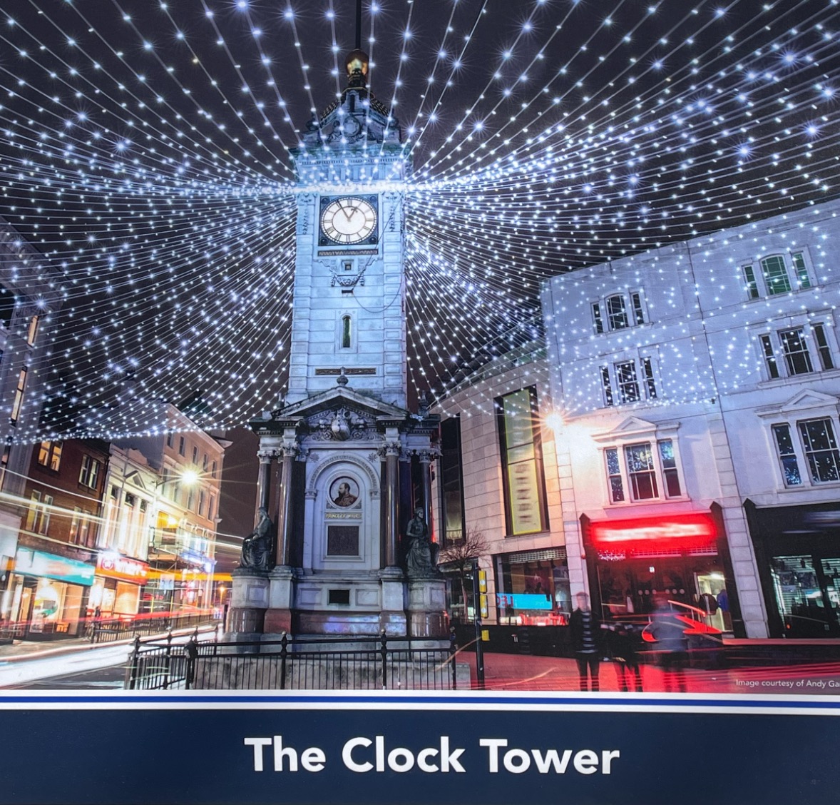
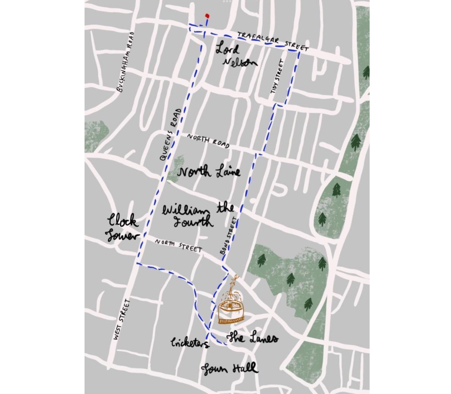
Thirty Walks from Brighton Station: Walk 3 The Lanes 1.5 mile circular walk via North Laine and Town Hall to The Lanes returning via Duke Street and Clock Tower. The narrow alleys in the centre of historic Brighton south of North Street are known as ‘The Lanes’ though confusingly accessed from the station by walking through ‘North Laine’ which has no historical connection. The original five great fields around the fishing village were tenantry ‘Laines’. This walk from the station to The Lanes follows North Laine’s mainly pedestrianised streets lined with a fascinating array of cafes and shops devoted to art, antiques, second-hand books, musical instruments, clothing and new age paraphernalia. After crossing North Street the walk enters The Lanes which exhibit similar commercial interests. On leaving the station descend Trafalgar Street and turn right at Sydney Street into North Laines. At the crossroads turn right along Gloucester Road then left down Kensington Gardens. At the T junction with North Road turn right then left into Gardner Street. At Church Street turn right then left along Bond Street. At the T junction with North Street turn left. Cross the road at the pedestrian crossing to enter the passage straight ahead signed ‘The Lanes’ continuing under the Jubilee Arch (2002) straight along the alley. Continue with Bath Arms to your right then left and right continuing to Prince Albert Street. Turn right into Ship Street and then left along Duke Street. At the T junction turn right up West Street and cross North Street with the Clock Tower to your left walking up Queen’s Road to Brighton Station. 1.4 mile/2.3 km


Thirty Walks from Brighton Station: Walk 4 Grand Hotel 2 mile walk via St Nicholas Church to The Grand Hotel returning via St Paul’s Church. The Grand Hotel opened 1864 to cater as it still does for Brighton’s richer visitors. Drinking Brighton's sea water was considered so beneficial every room in the Grand Hotel had three taps: one hot, one cold and a third for sea water pumped from below. On 12 October 1984 the Provisional Irish Republican Army bombed the hotel in an attempt to assassinate Prime Minister Margaret Thatcher who was attending the Conservative Party conference. Though Mrs Thatcher survived, five other people were killed. ‘The Grand’ was reopened 28 August 1986 when the Concorde supersonic plane flew over in salute. Go straight ahead on exiting the ticket barrier and turn right outside Brighton station continuing to the pedestrian crossing. Cross and go straight up Guildford Road to the Battle of Trafalgar pub and turn left along Guildford Street. Cross Upper Gloucester Road into Centurion Road. As the road turns left, continue along the passage to Mount Zion Place. Turn left then right into St Nicholas Churchyard walking around the church into Dyke Road. Turn left and then right along Upper North Street. Take the second left down Marlborough Street to Western Road. Cross into scenic Clarence Square descending into Russell Square. Turn left continuing to Cannon Place and then right walking down to King’s Road on the seaside. The Grand Hotel is immediately on your left. Continue along King’s Road then turn left up West Street up to the Clock Tower and ascend from there back to the railway station. 1.7 mile/2.7 km

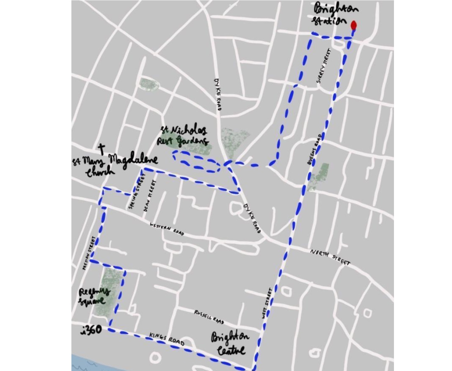
Thirty Walks from Brighton Station: Walk 5 Regency Square 2 mile walk via St Nicholas Rest Garden to Regency Square returning via i360 and Clock Tower. Brighton’s transition to a spa resort was accompanied by so-called Regency architecture of neoclassical style. Discovery of the benefits of sea water was main agent. Once used as an army camp, the grassed Square with its fine Regency housing now hosts an underground car park. It used to have immediate access to the defunct West Pier but is now dominated by the pier’s vertical successor, the i360, which offers more extensive sea views. Go straight ahead on exiting Brighton station ticket barrier and turn right outside the station continuing to the pedestrian crossing. Cross and go straight up Guildford Road and turn left along Guildford Street. Cross Upper Gloucester Road into Centurion Road. As the road turns left, continue along the passage to Mount Zion Place. Turn right along Buckingham Road and walk past St Nicholas Church to Dyke Road. Cross into St Nicholas Rest Gardens bordered by a neat array of headstones and fourteen Grade II listed burial vaults with matching doors, one openable. On return to Dyke Road turn right and then right along Upper North Street. Turn left down Spring Street, right along Hampton Street, left down Hampton Place and left along Western Road. Cross and descend Preston Street, with its fascinating variety of restaurants. Turn left to enter and view Regency Square and head down towards the i360. Turn left along the pavement of King’s Road. Turn left after Brighton Centre (1977) to ascend West Street and Queen’s Road back to the railway station. Sketch by Malcom Trollope-Davis exhibited on Brighton Station 2.1 mile/3.3 km


Thirty Walks from Brighton Station: Walk 6 Queen’s Park 2.5 mile walk to Queen’s Park via Hanover returning via Brighton Museum & Art Gallery. The picture is of the neoclassical remains of the Spa opened 1825 patronised by Queen Adelaide, spouse of King William IV, whose name provided the Park title. Exiting the ticket barrier at Brighton Station turn left then left again past the cycle storage onto Stroudley Road. Descend the stairs and cross New England Street into Ann Street down to London Road. Cross into Oxford Street continuing across Ditchling Road into The Level heading past the public toilets to the pedestrian crossing. Cross the A270 turn left then right for a steep ascent up Southover Street. At the mini roundabout turn half right up Montreal Road. Turn left down Albion Hill continuing across Queens Park Road to Queen’s Park. Turn right to continue along the lakeside and head for the South Road exit. Walk to the right down under the arch facing the Primary School and turn immediately right up Park Hill catching sight of the neoclassical edifice of Royal Spa Nursery School. At the top of the hill view the splendid main entrance to the Park. Walk in front of this across Queen’s Park Road then left down Upper Park Terrace. Enjoy the sea view before continuing down Carlton Hill. At Grand Parade turn left to the pedestrian crossing. Cross to Brighton Museum & Art Gallery continuing up Church Street turning right at Queen’s Road to head up to Brighton Station. 2.3 mile/3.7 km
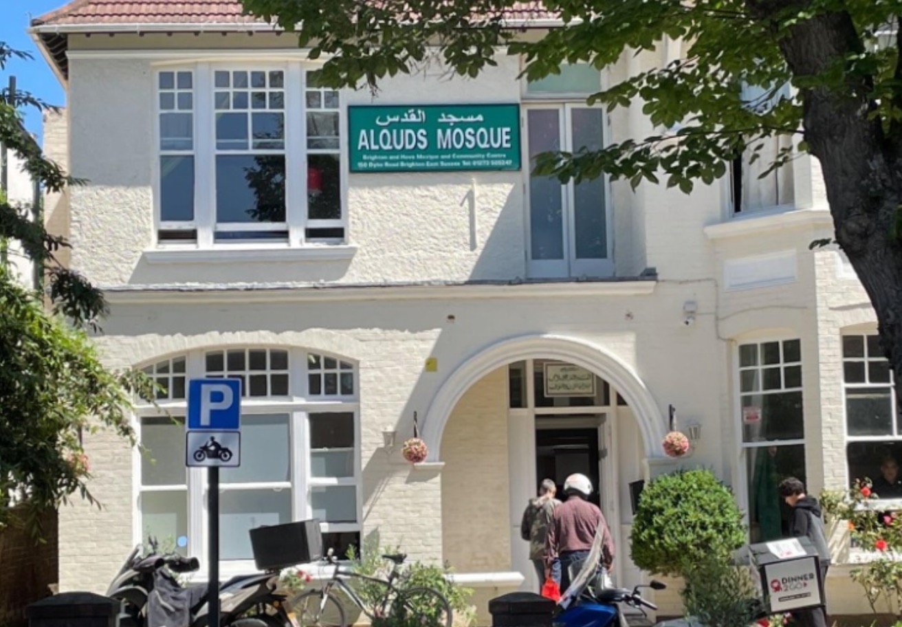
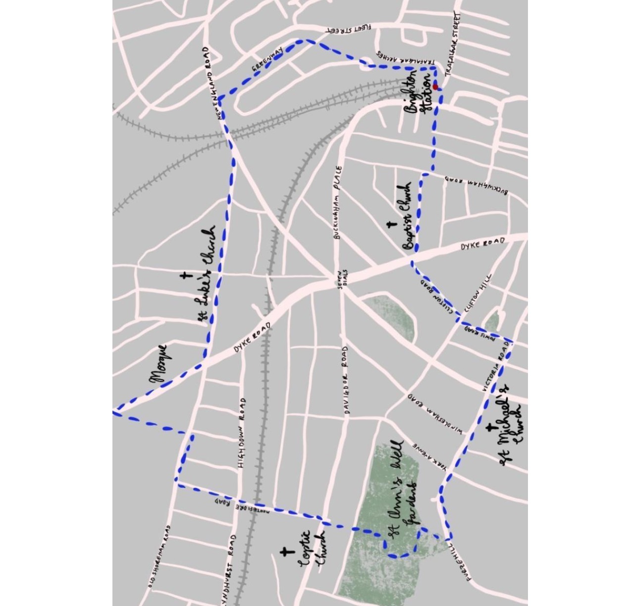
Thirty Walks from Brighton Station: Walk 7 St Ann’s Well Gardens 2.5 mile circular walk via Brighton Mosque to St Ann’s Well Gardens returning via St Michael’s Church. This walk presents a reminder of the hospitality of Brighton & Hove to minority groups. It passes the city’s first Mosque founded in the late 1970s as well as Coptic, Anglican and Baptist Churches and a memorial in St Ann’s Garden significant to the gay community. Exiting the ticket barrier at Brighton Station turn left then left again past the cycle storage and taxi rank onto Stroudley Road. Continue past the steps to enter Brighton Greenway. Descend to New England Road, turn right and continue right on the pavement up to the crossroads. Turn right up Dyke Road past Brighton ‘Alquds’ Mosque. Continue briefly towards Dyke Road Park, cross and descend Crocodile Walk back to Old Shoreham Road. Cross the road, turn right and after a distance left down Montefiore Road continuing across Highdown Road to its junction with Davigdor Road. Cross into the path to the left of the Coptic Church. At the bottom cross Nizells Avenue into St Ann’s Well Gardens where you can visit the LGBT memorial tree. Exit the Gardens into Furze Hill. Turn left and cross York Avenue into Temple Gardens. Continue across Vernon Gardens to St Michael’s Church (1862) on Victoria Road. Turn left immediately after the Church up Powis Road. Cross Clifton Hill and walk up Clifton Road. Turn right at Dyke Road then cross the road into West Hill Road. At the T junction turn right along Buckingham Road then left down Guildford Road descending to the forecourt of Brighton Station.
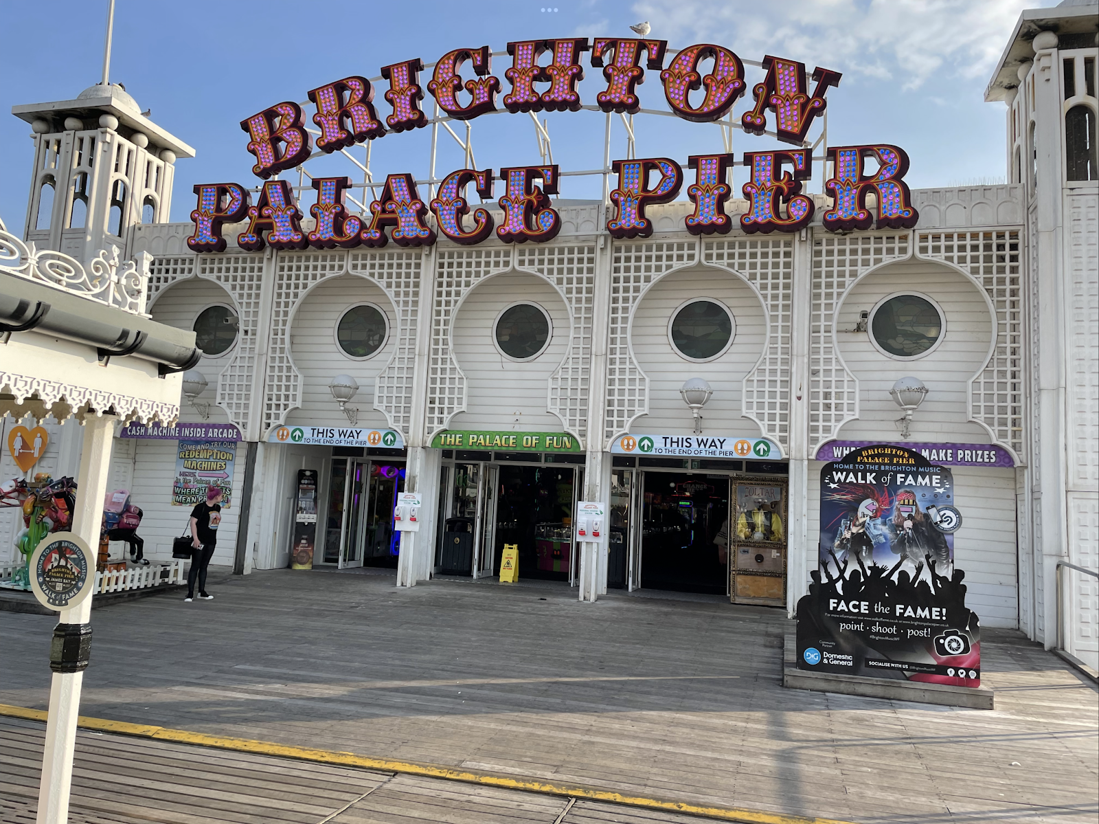

Thirty Walks from Brighton Station: Walk 8 Brighton Pier 2.5 mile circular walk via West Street and Promenade to the Palace Pier returning via Royal Pavilion and Trafalgar Street ‘Ah, dear Brighton - piers, queers and racketeers’ (Noel Coward). London’s love affair with Brighton traces back to the championing of sea bathing and sea air as healing remedies in the eighteenth century. Fuelled by royalty interest in Brighton grew so that a flow of up to 40 coaches a day grew from the capital leading to the arrival of the railway in 1841. In 2016 an estimated 4,650,000 people visited the Palace Pier which has gained fame through providing a context for films such as the gangster thriller ‘Brighton Rock’. Exiting the ticket barrier at Brighton station walk straight ahead down Queen’s Road. Cross North Street continuing your descent to the sea down West Street. At King’s Road you follow the invitation ‘Descend subway to beach’ then turn along the Promenade. Head up the slope onto Kings Road. Turn right to explore Brighton Palace Pier. Return to Grand Junction Road and cross to Royal Albion Hotel. Turn right and walk around the hotel into Old Steine where fishermen once dried their nets. Continue on the pavement, turn left into Castle Square and right before the roundabout into Pavilion Buildings. Head left at India Gate and take the second left turn walking away from the Royal Pavilion to the left of Brighton Dome onto New Road. Turn right and continue to Church Road. Turn left then cross into Gardner Street in North Laine signed for the station. 2.6 mile/4.2 km
Comments
Post a Comment